Anwendungen
 Scene
Scene


 1st Slide
 Branching Point
 Module: Anwendungen
 Sequence: lev0_start
 Branching Point: Applications. The practical heritage
 Slide: Lasers in the industrial fabrication

European Geostationary Navigation Overlay Service (EGNOS)
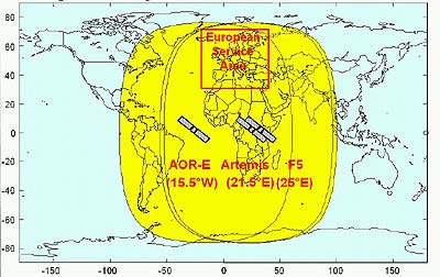
EGNOS is the European contribution to the first phase of the Global Navigation Satellite System (GNSS-1). It is intended to guarantee for the first time positioning standards agreed upon. This includes a message within six seconds about emerging problems.
The guaranteed reliability is an essential precondition of broadest civil use of satellite navigation, even in sensitive areas like landing aircraft.
EGNOS receives, evaluates and corrects the signals of both military systemes, GPS (USA) and GLONASS (Russia), and sends them out in a GPS compatible form via three geostationary satellites. Positioning becomes correct to within two metres horizontally and five metres vertically.
Together with the deployment planned for 2005 of the first satellites of the non-military European Galileo system, both accuracy and reliability of EGNOS become further increased step by step.
[ Sitemap ]
[ info ] This website was created by the MPI for the History of Science.